A Trip To Remember
(Press Play To Watch Video below)
It has been my dream for some time to explore the West. My gracious and lovely wife consented to go along with me. Together, we are on an adventure that will take us to who knows where?
We had a great send off this morning, Saturday July 9, from McDonalds. What better send off than from some of our loving grandchildren and children.

After our goodbys, Judy and I hopped onto the trike and away we went. We did get a late start but having breakfast with the kids was worth it.

For the first four hours, the ride was pretty boring. The eastern half of Iowa reminds me of central Illinois, flat and no scenery. The last couple of hours, we drove over small hills. Me made it to just East of Des Moine. We found a KOA and set up camp for the night.


As the sun settled in the West, Judy and I took our showers and headed to bed. I hope we sleep well tonight. We will need it. There is thunderstorms headed our way tomorrow. I can hardly wait. One nice thing about getting absolutely soaked while riding your cycle is you don’t have to stop to go to the bathroom.
If ever there was a night for perfect sleeping, it was last night. The weather was perfect. All of the windows in the camper were open and the freshest breeze that you could imagine. Unfortunately, Judy’s neck hurt her all night and I was up quite often with my head cold. My sinuses would not stop running. I would shove a piece of toilet paper up one nostril and the other one would start. I shoved toilet paper up both nostrils and my eyes started running. This is how I woke up this morning.

We took our time breaking camp and headed out on today’s journey. We didn’t cover much territory today. As we got closer to Omaha, we saw a sign that said scenic overlook so we pulled into the area to see what we could see. The first thing that caught our eye was this tall tower. We figured this would be our exercise for the day.

In the next picture, you will see flood waters from the Missouri River. They have had extensive flooding in this area.

This was approximately 2 miles from where we were and it was 10 miles from the Missouri River. It had overflown that much. As we left the scenic overlook, I realized that we needed gas so I pulled into the closest station. This particular station had been completely flooded out in 2007 and they were not taking any chances this time.


Continuing on North, we came across several places where they had to sandbag the sides of I-29 to keep the river from completely flooding it. It was weird driving along with sandbags on both sides of you.

The weather played havoc with us today as the temperature reached 96 degrees. I knew as bad as I was feeling that I would not have enough energy to set up the camper so I talked Judy into staying in a hotel tonight. I will go get some NyQuil and try to get a decent nights sleep.
What a great night sleep I had last night. That NyQuil put me out like a lark doris, like a lark. I had very little drainage today and felt better than I had in a few days. Judy on the other hand is still having problems with her neck. We stopped at a pharmacy for some more medicine but she is still quite uncomfortable.
The weather today was absolutely perfect with mild sun, temps in the low 80’s and at times, cloud covered. When we started out this morning, we were driving in the Missouri River lowlands where the soil is rich and smooth. Then we changed into some semi hilly regions and gently rolling hillsides marked with small ponds everywhere. Of course, there were hundreds of ducks on them and as I passed, I rolled down the window and hollered, “See ya in the fall.


One of our stops today was in Mitchell South Dakota. Mitchell is famous for its Corn Palace. Now I have heard of the Corn Palace for years so I knew that if we were this close, we just had to go by. I thought that the whole building was built with corn but such was not the case. It was rather unique though.

There were several pictures on the outside of the building and they were all made of corn. Part of it was from the cob itself, the husk, tassels, stalks, etc. They were quite artistic.


After leaving Mitchell, we rode for about an hour and I told Judy that I was going to stop at a Rest Stop to shut off my hearing aid. The wind noise was driving me crazy. As we were stopping, I asked her is she wanted to use the bathroom and she did. I told her that I would be at this picnic table when she got back. About an hour later, I woke up and she was laying on the other side of the bench waiting for me to wake up. She did tell me that I had done some pretty loud snoring.
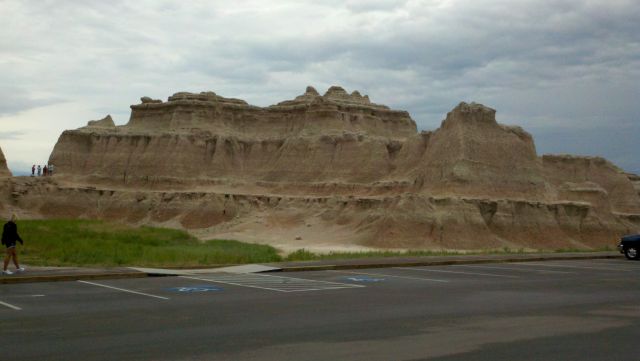
All winter long, I had been reading about the “Badlands”. I had seen pictures and thought that we would just ride through and keep going. Judy and I were both shocked at the beauty of this region. It turns instantly from gently rolling hills to this barren rock cragly looking creatures that are hard to describe. But the beauty of it all is the colors that are running through the rocks. This is hardly any vegetation and it looks like an abandoned gravel pit. Below is some pictures but it doesn’t come close to describing the beauty. We came over a hill and the majesty and beauty almost brought me to tears. Check these out:


Judy took most of these pictures while I was driving. We spent the night at a KOA beside the White River on the edge of the Badlands. The town is named Interior. So far, we haven’t seen a town. It is gently raining as we turn out the lights and close our eyes. Good night everyone.
Of all things to wake me up this morning, an owl. Whooo Whooo! And then from a distance, another, Whooo Whooo!. They kept this up and it was hardly light. I wanted to holler,”Meeee Meee, that’s Whoooo your keeping up. I knew that it wouldn’t do any good so I just left it at that, turned over in bed and slept restfully for a full 3 minutes more.
We went for our morning walk around the campground and ran across this neat camper called a Tear Drop. It was a lady and her elderly aunt from Illinois and they had been staying in it for several days while exploring this region.


She told us that inside was a queen size bed. The back of the camper opened up and there was a kitchen with cooler, 2 burner stove, and several drawers for storing items.
As usual, we took our time breaking camp. It was almost 11:30 before we left. It wasn’t until later that I realized that we were in Mountain time and it was only 10:30. We decided to drive back into the Badlands and take the 27 mile ride to Wall, S D. Of course Mother Nature (not that one) took over and it took us over 2 hours to drive it. The scenery was once again breathtaking and we had to stop every couple of miles and get off of the bike and look. At one point, we had a young lady with long hair take our picture. Keep in mind that the wind was blowing quite briskly. I guess we should be happy with what we got.

I was watching her fingers to make sure that they didn’t get in front of the lens and her hair must have blown in front just as she hit the shutter. We did get someone else to take our picture later. I’m not one to brag but I will have to admit, that is a good looking couple.

Here is a few more shots of the Badlands.


After leaving the Badlands, we headed for the big town of Wall, S.D., population 818. That is what the sign said. No trip out West is complete unless you visit Wall Drug. It was started in the earyl 30’s during the depression. To read more about the history of this great story, click on the link below.
http://www.walldrug.com/t-history.aspx
We spent several hours in the store and acted like a couple of teenagers. Judy sure lets her hair down when she gets out of town and away from her kids and grandkids. Below are a few pictures we got just before they kicked us out.


After leaving Wall Drug, we headed for the KOA located near Mt. Rushmore. this place is huge and we will be telling more about this tomorrow. Goodnight everyone.
The KOA at Mt. Rushmore is one of the prettiest and largest campgrounds that we have stayed in. This is looking out of our camper on Wednesday morning at the surrounding hills.

Here is our home away from home.

There were many activities for the kids to do, rent bicycles, water slides, pan for pretty stones, water park, horse back riding, boat riding, fishing, and last but not least, making noise until the early hours of the morning.
THE REST OF THE STORY.
In 1883, a young lawyer from out East went to the Black Hills of South Dakota to check on mining titles for the company that he represented. While checking titles, he became friends with many of the independent miners who were prospecting for the new gold that had been discovered in these hills. He started doing some pro bono work for the miners and helped them make sure that there titles to the land there were prospecting was legal. He becamed well liked for all of the help that he was doing for the “little man.” While hiking around the various claims one day, he came upon a very high peak. He asked one of the miners what the peaks name was. The miners told him that it didn’t have any, but said that they would just name it after him. And so they did. Clarence Rushmore Peak later became Mt. Rushmore. He was also the largest contributor of gifts to the sculptors who did the carving at the Peak. And now you know the rest of the story.
We were on our way to visit Mt. Rushmore when we came upon this pull off beside the highway. Judy is much more stronger that I had realized and I captured this picture of her holding up this huge stone with just her shoulder.

Here is a challenge for you. What else do you see in the picture of our trike.

More pictures of Mt. Rushmore.


An interesting story that we heard on our tour of the Presidents was how Bill Clinton and Barrack Obama felt jilted out of not having their likeness up there with the other presidents. The commissioned a sculptor to get their likeness up there but since neither had the money to pay for their individual face, they had the sculptor use parts from each other and put them together to create one. Below is a picture of the finished product.

I believe that might be a close up. After viewing Mt. Rushmore, we took a ride into Custer State Park. See if you can guess what song we are thinking of by looking at the next three pictures.

 Plus this.

Did you guess the song?
While on our tour, we found the buffalo. It was neat to see so many of them and to have them so close to us. We did feel pretty vulnerable at times while they were marching past us since we didn’t have the safety of a car.


The guy above came to within 10 feet from us. He was a big brute.
We also came across some donkeys that roam free in the park. Originally, they were used to take people on rides through various locations in the park and when they stopped that practice, they just turned them loose. They now beg for food when they see tourist.


After our ride through Custer, we rode on the Needles Highway. It was named for the long needle looking rocks that are native to this region. We also had to drive through several very small tunnels.


We ate supper this evening in Hill City, S.D. at Desperado’s. Great steak and it helped us sleep peacefully after of full day of driving.
After breaking camp at Mt. Rushmore KOA, we decided to head up to Rapid City to buy a camera. My sister had bought a new one just prior to our meeting in the Smokies and we fell in love with it. As luck would have it, we found the exact one and bought it. After leaving Rapid City, we headed for Sturgis S.D. Sturgis has a population of 6600 people. But during the first or second week in August, every Harley owner converges on the tiny town to have a fun filled week partying.


It was extremely hot and miserable so we just drove through town once and headed down to Deadwood, an old mining town. We stayed at the KOA and met another couple who had a pop up camper, very much like ours. They were from Minnesota and traveling just like we are. Not in any hurry to be anywhere.

For supper, we drove into the town of Deadwood and ate supper at an old western saloon/hotel. It was kind of neat but the food and service fell quite a bit short of good. We strolled downtown until after dark then headed back to the campground. Another long day but still had fun.
After leaving Deadwood, we headed to Cody WY. We crossed the state line and ran into the most beautiful nothingness that we have ever seen or hope to see. It was just miles and miles of blah.


In order to get to Cody, we had to cross the Big Horn Mountains. It was a long drive but pretty. Here are some pictures of the roads we traveled on in the mountains.


As soon as we arrived in Cody, we set up our campsite. Immediately, we had people start coming over to see our camper, some even came back and asked many questions about it and was so amazed that all of that could come out of that little trailer.

All winter while planning this trip, I kept hearing and reading about 2 highways in Wyoming that was a must ride. Chief Joseph Highway and Bear Tooth Highway. Bear Tooth Highway was voted the number 1 rode in the nation by motorcyclist to ride on. I couldn’t pass up the opportunity.
Saturday morning, we left Cody and hit Chief Joseph. That highway itself is just beautiful and climbs up from a valley a great height.

We stopped at a scenic stop and the view was spectacular.

This next picture appears to have me pointing at something but I was just trying to show Judy that I had flung the buggar off of my finger and I didn’t have it on there anymore.

We were getting hungry and came upon this restaurant out in the middle of nowhere. As luck would have it, the town that we would be ending up in was having a Harley Rally. They had estimated 10,000 bikes there that day and this restaurant was one of the riders destination that day.

We had a hamburger and braut and sat out on the back porch to eat our lunch. It was overlooking a branch of the Yellowstone River.


After leaving lunch, we started on up the mountain and came across this mountain stream.

Judy decided to see how cold it was so she walked down and put her hand in the water. This next picture says it all as you can see in her expression.

She said it was colder than a witches waduby, whatever that is. There were also wild flowers growing all over the mountains and we got a picture of some of them with other mountains in the background.

It was amazing just how much snow was still on the mountain. We had heard that they had to close the highway 2 weeks before because it got snowed in. The following are some snow pictures.

That snow was so cold, it made my hair stand on end.


Part 2 of Bear Tooth Highway tomorrow.
Bear Tooth Highway was an incredible road to ride. The views kept getting better but the road became more challenging. There were many lakes on top of the mountains. Below are a few.


Sometimes, the road was a little too close to the edge for our comfort, but we couldn’t turn back.


In order to come down from these mountains, or for any mountain, you have to do some zig zagging. We came across one part of the mountain that had previously had a rock slide that had wiped out the same road twice. Check these out.


As I said earlier, the town that was at the end of the highway was having a Harley Rally. As we rode down main street, Harleys were lined on both sides.

From this town back to our campsite was 70 miles and we were ready to get back.
We headed out of Cody WY about 10:30. By the time that we got out of town, it was 1:30. We had to get gas, Walmart for supplies, and lunch. It was fifty miles from Cody to the East Gate of Yellowstone. On the way, we had to go through a couple of tunnels.

After driving 52 miles, we saw the sign that we had been waiting for.

The following are some pictures that we took driving through the park to our campground.


We crossed the Continental Divide several times. It is amazing that when rain or snow falls on the mountain, it can run into the Pacific Ocean, and a few feet away, when that rain or snow falls, it will run into the Gulf of Mexico.


Here are a few shots of wildlife that we saw.


We were pretty tired when we arrived at the campground. Check out what we did on Monday.
Our destination for today was supposed to be Old Faithful. But before we got there, we took a driving tour of some of the geysers. Here are some pictures.


When we arrived at Old Faithful, we got a good parking spot right up front. Hundreds of people were already there and hundreds more were arriving.

Here is the old lady when she is docile.

And when she gets all steamed up.


We decided to take a tour of the Old Faithful Lodge. It was built a long, long time ago. The architect decided that it should look rustic like its surroundings. Here is some pictures of the craftsmanship and design.


After viewing Old Faithful, I figured that we had time to travel to the Northern part of the park. This would require 3-4 hours traveling round trip. The first memorable thing that we came to was Gibbons Falls. It was beautiful and with the lovely woman sitting on the stones in front of it, it was just downright gorgeous.

I was hoping to see a moose or bear this week but this is the largest animal that I saw. It was a bull elk.

Soon after seeing the elk, we were driving across an open part of the park and came upon some mules running alongside of the road. Evidently, they use these as to take tourist on rides back in the wilds. Apparently these mules got away from the owners because later that night, we saw the ranger and some cowboys tying them up to a horse trailer.

Here is some more scenery on our way to Monmouth Springs to view some more geysers.
Part III will show more pictures of geysers.
On our way to Monmouth Springs, we saw some great scenery followed by some more geysers.


Some dried up minerals from the geysers.

More geysers that had actually dried up and opened somewhere else.


Snow and ice? No rhino breath, just some more minerals that had deposited on the earths crust.


Geyser mineral taking over a tree.

On the way back to the campground, we came upon an elk herd.

This is not snow at a high elevation, it is just white stone.

While driving along one of the rivers in Yellowstone, we came upon a single elk. Notice the collar on her.

A mule deer doe.

An ending of another beautiful day with the sun setting in the West behind the mountains. While I am driving, Judy has been in the back taking pictures of the scenery and of things that I cannot see. It is not until I get back to the campground and look at the pictures that I can see everything that I have missed. She has done an outstanding job of capturing our vacation.

It was well after 11:00 after we had gotten up, had breakfast, and prepared ourselves for the day. It was decided to head South to Jackson Hole WY. The trip would be 130 miles one way and the speed limit in Yellowstone was 45 miles per hour at the best. Sometimes, it is lower. We figured that it would take us 3 hours to get there, one hour to eat, and one hour to tour the town. The Tetons was something that most people I talked with said that we had to see. With my own personal photographer in the back seat, off we went. In 1988, a fire swept through Yellowstone like no other. It destroyed 793,880 acres of timber. That equaled 36 % of the park. Below is a picture of what the park looks like today.

On the road to the Tetons.

Our first look at the Tetons.


We were driving down this highway and looked over and saw this good looking couple standing in front of this sign. We pulled over and snapped a couple of pictures of them.

We finally arrived in Jackson WY and found it to be an attractive town. Note in this next picture the ski hill in the background.

The architecture of this building caught my eye.

At each corner of the town square, they have this entrance made out of elk antlers.

Our 2 hours were up so we saddled back up and headed out of town going North. As we were passing the Tetons again, things started looking pretty black in the West. Judy said, “I believe we are going to get wet.” I said we could outrun it. Check out this storm.

It wasn’t 10 minutes later that we got bombarded with the awfullest rain, sleet, blowing wind, and the temperature dropped to 52 degrees. We were wet clear through to our skivvies. By the time that we got back to our campsite, we had pretty much dried off. It was just getting dark when we got to the camper.
After packing up everything, we started for Glacier National Park. We knew that we would not make it in one day so we decided to spend the night at Great Falls MT. The trip there was pretty and peaceful. We didn’t take any pictures on this part of the trip because our camera got wet the previous evening and wasn’t working properly. This is our campsite in Great Falls, right next to the shower house.

Although we had to use the heater again, we had a great nights sleep. After breakfast, we started out for St. Mary MT. where we would be spending the night before going over the mountains and through Glacier. On our way to St. Mary, I spotted some wild swans and some pelicans.

There were many little potholes like these with ducks and geese in them. About half way to Glacier, we came into this small town and saw this restaurant. It was looked very cute with all of the flowers so we decided to stop and eat.

Here is another flower among flowers.

We went inside for some vittles and I told Judy that I was going to go out of my comfort zone and order a sandwich I had never ordered before. It was a grilled chicken sandwich with ham and pineapple. It was delicious. It filled me up so much, I couldn’t even order a piece of pie.
Judy said she was going to go out of her comfort zone too so she ordered this 10 layer veggie sandwich. The picture below shows her with just half of the sandwich. Notice her fist next to the sandwich to give it proper perspective. I call it a knuckle sandwich.

When we were leaving this town, we ran across 2 dinosaurs.


The ride through this area was certainly boring. I just locked my steering and took a nap.

THINGS TO DO WHILEST IN OUR TOWN.


YOUR DOIN IT!
The towns that we went through were lacking in everything. But I imagine that most of the people that live there like it and it is home to them.
We spent the night in the town of St. Mary MT. It rained off and on all night. It was windy and miserable when we woke up. We had to wait until a rain storm had passed through before we broke camp.

A river we crossed just before entering Glacier Park

Entering the park, we pose before the sign. We each had a tee shirt, long sleeved shirt, sweatshirt, leather coat, and rain pants and jacket. And we were cold. It got down to 43 degrees and rainy and hail on top of the mountain.

Here is a bear sign. Take it for what it’s worth.

Below are several shots Judy took while going over the mountains in Glacier.


We spent the night at Missoula KOA and ran across some people that we had camped near in Cody WY. They too had a bunkhouse camper and we spent some time catching up on where they had been since we had last met. They are traveling across the country and have been since May. They think that they will be home about September.
Our next destination was going to be Boise ID where we were going to spend a few days with our friends Mike and Miriam Luginbill. We went to Olivet together and they had visited us in May after traveling across the U.S. After looking at the map and talking with several people, it looked as if our fastest way to Boise was going through the mountains at Lolo Pass. The only drawback would be that there would be not service of any type for over 90 miles. We decided to take the chance and do it anyway.
Route 12 is the route that takes us through Lolo Pass. It was a good feeling when we saw this next sign. However, we had a long long way to go after that.

And this next sign concerned us also.

This road turned out to be a motorcycle riders dream.

The dream was short lived when we came across this next sign. The sign before said that there would be fresh oil and then this sign.

Lolo Pass started out following a small stream that measures approximately 20 yards across.

By the time that we got to the end, the river looked like a lake that was about 200 yards wide.

For lunch, we found a grove of cedar trees along the river and they had a picnic table. We walked back among the ferns and large cedar trees and ate. It was a little eerie being that far off of the road.

We came across signs like this quite often. My curiosity got the best of me so just before the next one, we pulled over.

We must have stayed there for over an hour and the only thing we saw was monopoly, checkers, and mexican train. Not exactly the game I was looking for.
This next sign would have really concerned me but I had about 3/4 tank of gas left.

We stopped often to get a drink or snack from the cooler. Judy caught me resting against a tree looking up this tall hill.

That 32 0z mug could only find so much space inside of my body. There wasn’t very much traffic so I just walked into the weeds. Unfortunately, when you trust your wife with the camera, you are completely at her mercy. And she showed NO MERCY.

The landscape started changing slowly and turning into a more gently rolling hills. Notice the road in this picture.

Then the landscape changed again and we drove through thousands of pines trees. The smell of pine was so strong that you could almost taste it. It really was a pleasant smell.

We spent the night at a campground in McCall ID. This was the first time that we would stay in a campground that wasn’t KOA.

This wasn’t the best campground and it was full of high school girls who were playing in a softball tournament. Before we left camp, I decided to take a shower and clean up. While taking a shower, I kept hearing this baaa baaa sound. At first, I thought that someone was having a hard time in the stalls. After taking my shower and drying off, I walked out of the shower room to see a goat tied just outside the shower. That was a first.

It was hard to see the goat but he really was there.
Mike and Miriam had told us about a ski resort that was being built that had gone bankrupt. The company had also started building million dollar homes and everything came to a complete standstill. We drove up to see these homes and it was a shame to see all of these homes standing empty and partially finished.


After traveling in temperatures that reached 101 degrees, we reached Mike and Miriams house.
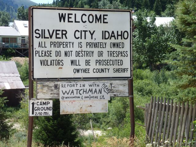
On Monday, our friends Mike and Miriam asked if we would be interested in going to a ghost town. They had been wanting to explore around there so off we went. When we arrived at the turnoff, we traveled on paved road for 6 miles and then dirt and rock another 14. The landscape started with desert like terrain with some irrigated spots as shown in the following picture. It then turned into barren land.


From there, it turned into hilly barren land and then into hills with green trees and bushes.


Climbing slowly up this mountain, we finally came around a bend and there was the town that we had been looking for.


Below are 2 pictures of the town during it hayday in 1900 and another picture taken in 1950. Notice the difference.


The next picture is of the residential area now. No one lives there full time now, just weekends, holidays, and summers until the snow falls in the fall.

Part of downtown.

The Grand Hotel is the largest building in town. They still take boarders and serve meals daily, hamburgers and light sandwiches.


I would hate to have to make an appointment every time that I needed to use this.

This was an interesting day and we enjoyed it very much. It was disheartening to see a growing viable town of 100 years ago to end up almost nonexistent today. For more reading on Silver City, click on this link. www.historicsilvercityidaho.com
Tuesday found us just chilling out at Mike and Miriam’s house. I did have to go have a new tire put on the front of the trike because it was wearing badly. Tuesday evening, Mike and Miriam took us to a restaurant in downtown Boise called “Donnie Macks Trailer Park Cuisine. It was in an old gas station and the decor was old junk. Below are some pictures.


Note the waiting area. Old couches and end tables.

I thought the old car with table inside was the best but there was already someone using it. Note that the hand rail going in is out of old exhaust pipes. Right next to the stairs going up to the car is a square box. There is a whole car that has been crushed inside the box. The make use of old shower curtains to hide their supplies.


Here we are waiting for our name to be called.

Wednesday morning saw us leaving Mike and Miriam’s and starting our trek home. I had been thinking about skipping Colorado and going home via route I-80. That would have been the fastest way, but decided at the last minute to go via Colorado. Mike and Miriam had showed us a way to cut some time off of our journey and they said the road was beautiful. It was in a canyon most of the way. We will have to admit that it was beautiful, but we were not able to take any pictures because it rained the whole way through the canyon. We looked like 2 bananas riding on a trike but we stayed dry. The sign below tells the story of how straight the canyon was.

When we finally came out of the canyon, the sky started to clear and the road became desolate and blah. Judy did capture a picture of a rainbow in the distance.

However, we came over a rise and were in the middle of what looked like a crater.

And one last shot of the rock formations that we saw today.

Wednesday evening saw us camping in a small town in Utah called Green River. I don’t know why they call it Green River because that river was extremely brown. After getting our camper set up just before sundown, we walked next door to a nice restaurant for supper. Judy and I shared a pork chop supper and under protest, she also shared a chocolate cake covered with fudge and whipped cream. I will have to admit, I did eat the largest portion of it.
The day before while we were still north of Salt Lake City, I had to stop at a rest stop and nap. Upon waking, I read this sign about the Great Salt Lake that was here eons ago.

After breaking camp in Green River, Utah, we headed for Colorado. We had heard stories about Vail Colorado and how the movie stars all go there for skiing.

Needing gas, we pulled into a gas station and while we were pumping gas into our trike, guess who pulled in to get gas also. I was completely shock but standing next to the pumps next to us was Harry Bonnadorche. He never acted in the movies but he did stay in a Holiday Inn Express the night before. We were very fortunate to have seen him.
Soon after leaving Vail, we ran into the beginning of a tremendous traffic jam just prior to climbing the summit of the Rocky Mountains.

Besides the traffic backing up, Judy started noticing the weather was changing.


We could have walked up this mountain faster than we were driving. On top of that, the trike started overheating. There were trucks and cars and semis pulling over because they were overheating also. When we finally crested the top and started down, we came to this tunnel.

This tunnel carries I-70 under the continental divide 11,000 feet above sea level and is one of the highest vehicle tunnels in the world. It is 1and 3/4 miles long, and I thought that we would never come out of it. This is what the inside of the tunnel looks like.

When we exited the tunnel, we were so high up that it had just snowed. In the following pictures, you can see the light snow on the road and the next picture show light snow on the side of the mountains.


We had a hard time finding a camp ground that night so we spent the night just west of Denver.
We had to find a Honda shop and buy some coolant. We also met up with and had lunch with some of our old friends from Olivet days, Ted and Jane Bryant. I don’t mean they are old. I just mean that we had known them a long time. We had a great time catching up and the meal was good also. We left Ted and Jane and headed to Estes Park.

Estes Park was a neat town that we had heard about for years. We spent several hours there but for some reason, we didn’t take any pictures of the town. After leaving Estes Park, we followed Highway 34 which followed a river and canyon. The drive was slow but beautiful.

On our way to Ft. Collins KOA, Judy spotted this hot air balloon.

When reading the description of this KOA, it said very quiet surroundings. I must have missed the fine print where it said, “that is if you wear ear plugs.” We could hear the interstate traffic all night, and sometime during the night, the wind shifted and started blowing the sweet aroma from a cattle stockyard into our camper. Now I don’t mind the smell of cattle or farms, but this was so thick, I could taste it in my mouth. And it didn’t taste like chicken.
We rose early so we could beat the traffic through Cheyenne, WY. It was their Rodeo Days which featured the worlds largest rodeo. We beat most of the traffic and turned East for our final 2 days of travel. Each state that we came to just meant that we were that much closer to home.

Much of Nebraska was flat but we started to see lots of corn fields. We were also getting back into the humid midwest which we had not missed for several weeks. We spent the night just west of Omaha Nebraska and got a good nights sleep.
Day 22 of our vacation to visit parts that we had never visited before. Hopefully, this would be our final day on the road. The weather was hot and muggy when we set the camper up last night. We didn’t use the air conditioner because we knew that as soon as the sun went down, the temperature would drop. It didn’t drop as low as we thought but the temperature was very comfortable. However, being that we were back in the midwest where the humidity was ever present, it didn’t let us down this morning. When we woke up, the dew was so heavy and the fog was so low that I knew we would be having trouble putting away the camper without having plenty of moisture on it. We were a little hesitant to start out in the fog, so we decided to just drive slow enough to be able to stop if need be and fast enough so no one would run over us. This is what it looked like this morning.


Finally, the sun started burning away the fog and we got our glimpse of the first sun.

We still had 2 more states to hit so on we drove. Oh, the feeling when we saw this one.

When we saw this sigh, we knew that we only had 100 miles until we got to our exit. Illinois welcomed us home with temperatures in the high 90’s and humidity that just would not leave us dry.

After a brief stop so I could wake up and hydrate myself, we saw that sign that we had been dreaming about. Our town! Oh how we love this place. It was great to be home.
After resting for a week and looking back at all of the places that we have been, I thought that I would look back over the pictures and reminisce about the places and things that stood out to me.
One of the things that I intended to put into our blog was about the time that we were staying at Mt. Rushmore KOA and they had “All The Pancakes That You Can Eat For $3.00” thing. Since our campsite was just across from the pancake tent, I decided to go over the first morning and have me some pancakes. Mike Luginbill had told me about this setup so I just had to see for myself. They feed many people and have to make many pancakes in a short period of time. There has to be a system or routine for them to follow to do this so the pictures below show it. They have this machine that dumps the pancakes on the griddle and by the time they get the last pancake on the griddle, it is time to start turning over the first ones. They can cook 60 pancakes at a time.


Believe it or not, I only had 3 pancakes. They were good but my appetite just wasn’t up to par yet.
This particular campground was just superb. Our setup was very accommodating.


Our camper (Bunkhouse) was quite comfortable and roomy. We never ran into any problems with it.
There was one instance on our trip where I almost lost my head.

Just prior to this, we had our first experience with “The Badlands.” I still cannot get over just how beautiful they were. I realize that everyone has their own version of beauty and these were mine.


Needles Highway was another place that stood out for me. We rode it at the end of a long day, but the high pointed stones and mountains left an indelible impression of me. Note the rock that is balancing on top of one of the pointed stones. I wonder just how long it will remain there until if falls.


I’ll never forget the herd of antelope that we encountered just outside of Great Falls Montana. I got a few pictures before they decided to take off and show their light colored rumps.


Bear Tooth Highway in Montana and Wyoming was by far my favorite. I somehow did not show the amount of snow that we encountered on top of parts of the mountain.

It was unbelievable that in the latter part of July, there would still be this much snow. One of my favorite photos is of my wife holding a snowball on top of that mountain.

A restaurant that we found in a small town in upper Montana had the most beautiful flowers that I had ever seen.

By far, the highlight of this whole trip was to have the love of my life with me. Judy was my second set of eyes and ears. I had the privilege to have her by my side and to experience this wonderment with me. The final picture places her standing beside some flowers at this same restaurant. She is as pretty to me as these flowers are. I am a very blessed person and thank God for the opportunity to see all that we saw and for the safe journey.
